

")
Here at Best of NJ, we’re searching for the best hiking trails in New Jersey. From gorgeous views and unique wildlife to lush greenery and challenging trails, we’re tracking down NJ’s best hikes. But we’re not just telling you to take a hike from our office chairs, we’re hitting the trails ourselves! Today, we’re showing off the Mount Tammany trail in the Kittatiny Mountains.
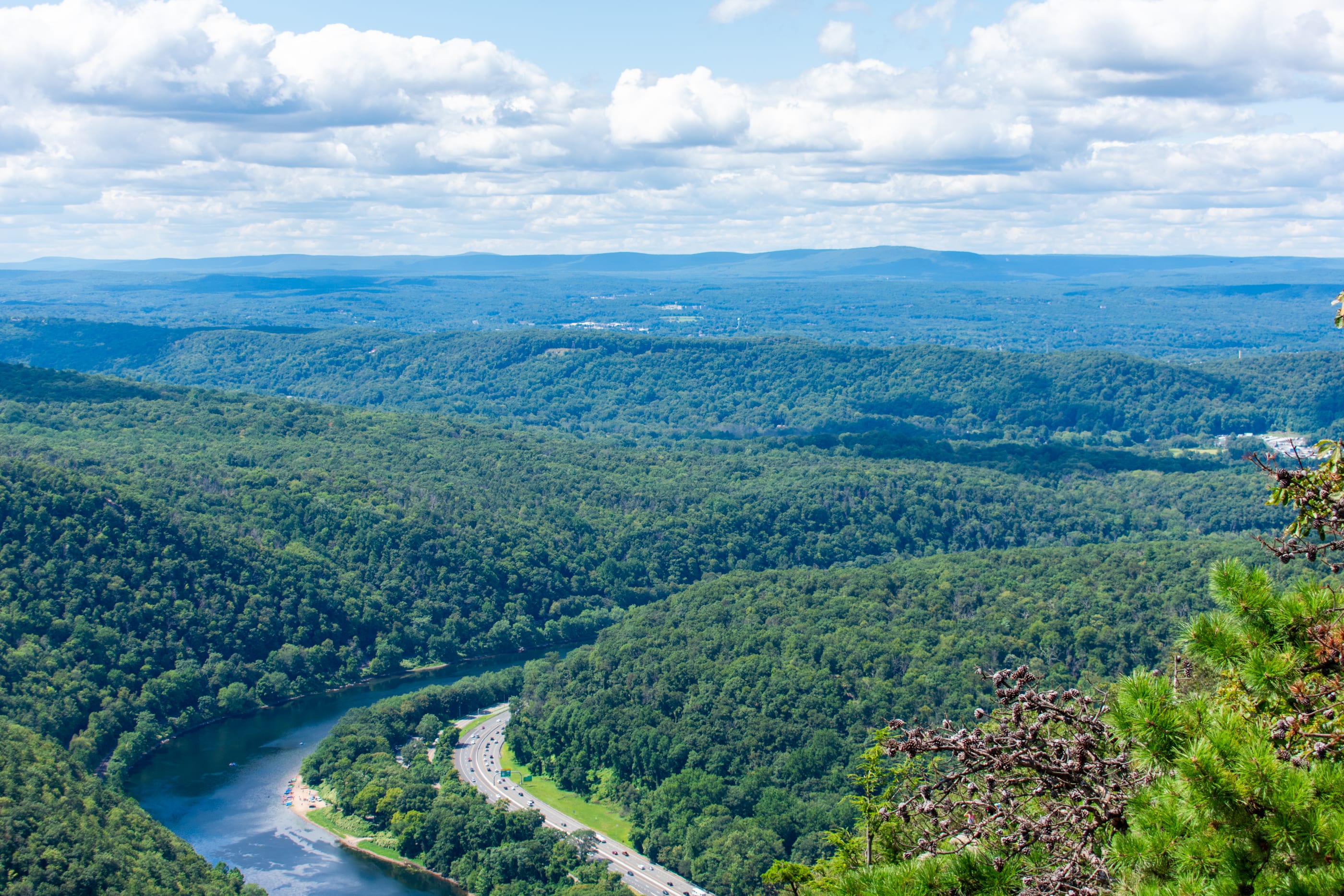
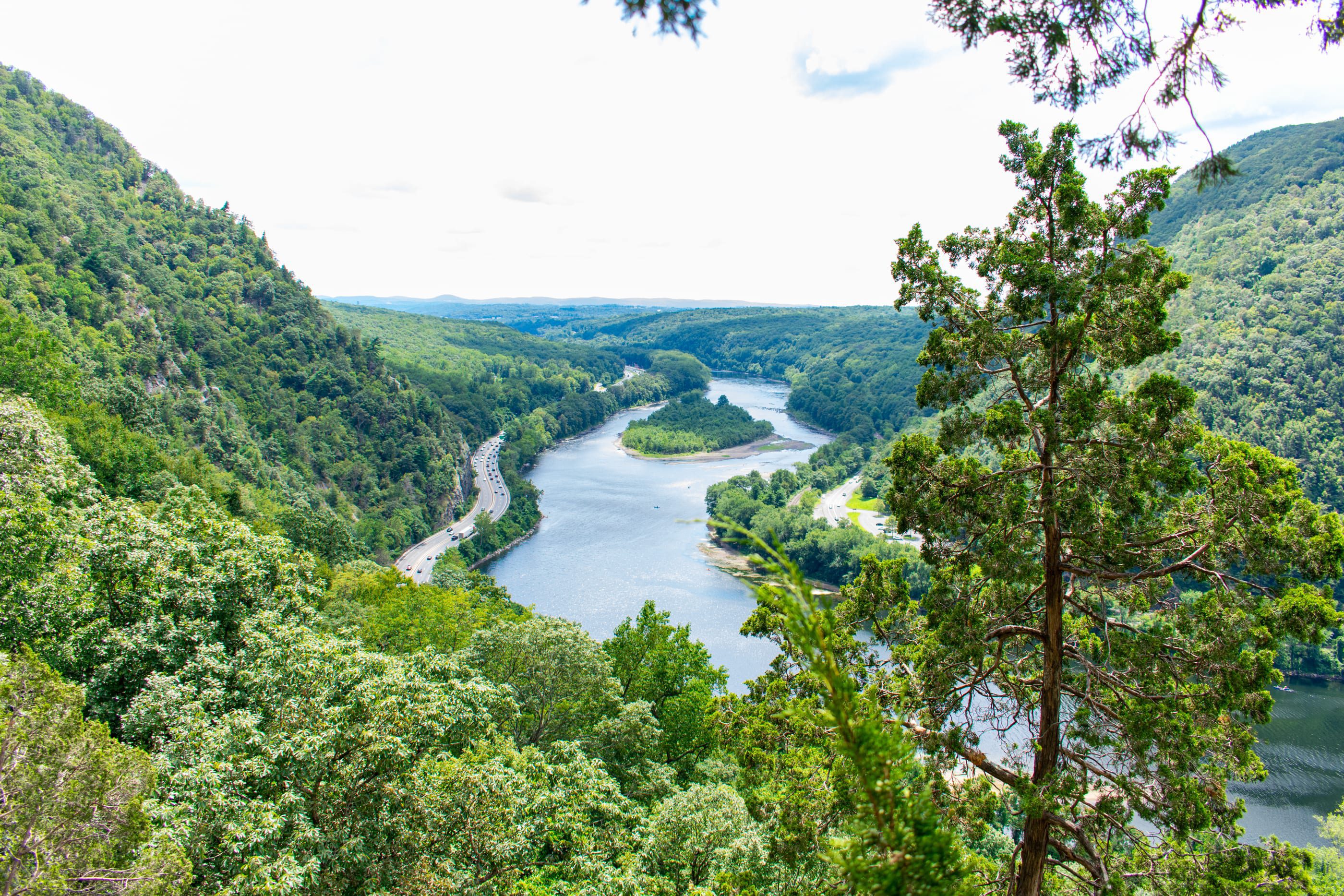
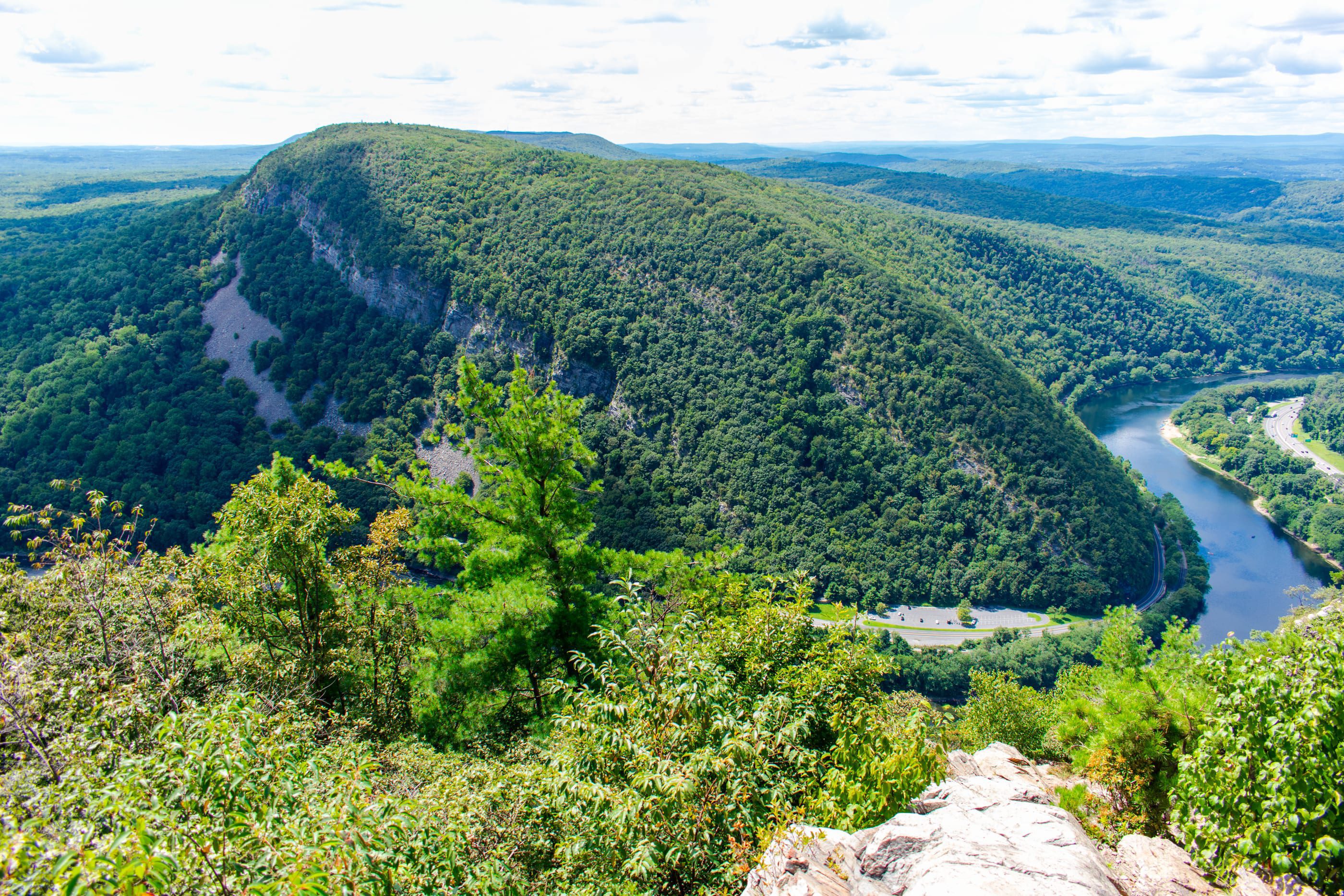
If you only get to take one hike during the fall season, make it this one. From the summit of Mount Tammany, you can see Mount Minsi and the greenery of neighboring Pennsylvania. As the leaves burst with color, it’s a remarkable sight.
More from Best of NJ
Trail Info
Mount Tammany is the southernmost peak of the Kittatiny Mountains. The mountain range is in Warren County and forms the east border of the Delaware Water Gap. The peak gets its name from Chief Tamanend of the Lenape; the indigenous people of modern-day New Jersey and eastern Pennsylvania.
The trail to Mount Tammany sits in the Worthington State Forest. This 6,660-acre state forest is home to the popular Delaware Water Gap National Recreation Area. But don’t worry, this hike is only a small portion of that. In fact, the hike to the summit of Mount Tammany is relatively short, at just three and a half miles.
You’ll need to access the state forest via Interstate 80. After doing so, you’ll find that Worthington State Forest has a few parking lots; so if one (or more) is full or blocked off, just keep following the signs to the next one. Worst case scenario: you’ll have to cross the street (under a portion of I-80) to access this particular trail.
The Dunnfield Creek parking area – the one you’ll be looking for – sits on the I-80 west side. However, if those lots are full, you’ll have to park at the Kittatiny Point Visitor Center; which is on the opposite side of the highway. In this case, you’ll have to take the next exit, then loop around (parallel to I-80 east) and bare right toward the visitor center.
Which Hike to Take
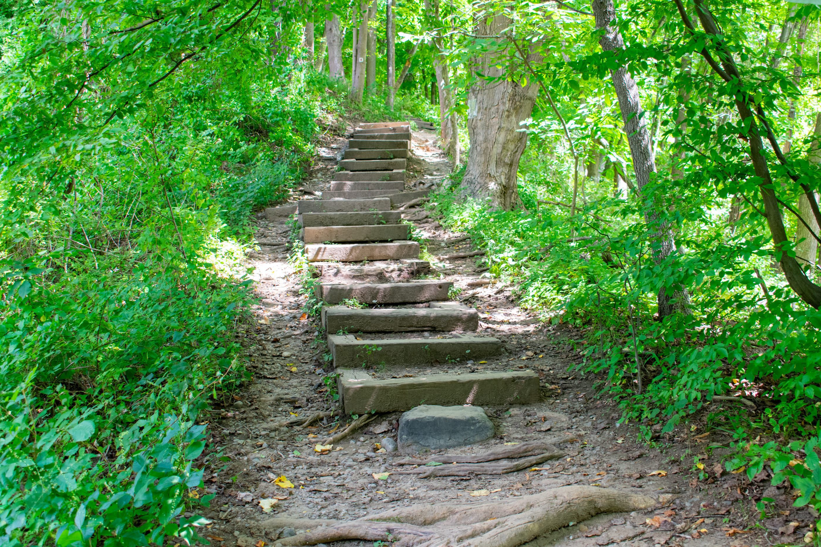
The best way to hike Mount Tammany is up the Red Dot trail and down the Blue Dot trail. We say this for a few reasons. First, you get to experience two very visually distinct trails, which you’ll read about shortly. Second, and more importantly, the Red Dot trail is difficult to travel down; it can get very steep, and hiking up it is easier than going down. For a simpler hike, you can go up and down the Blue Dot trail, but this isn’t as much fun.
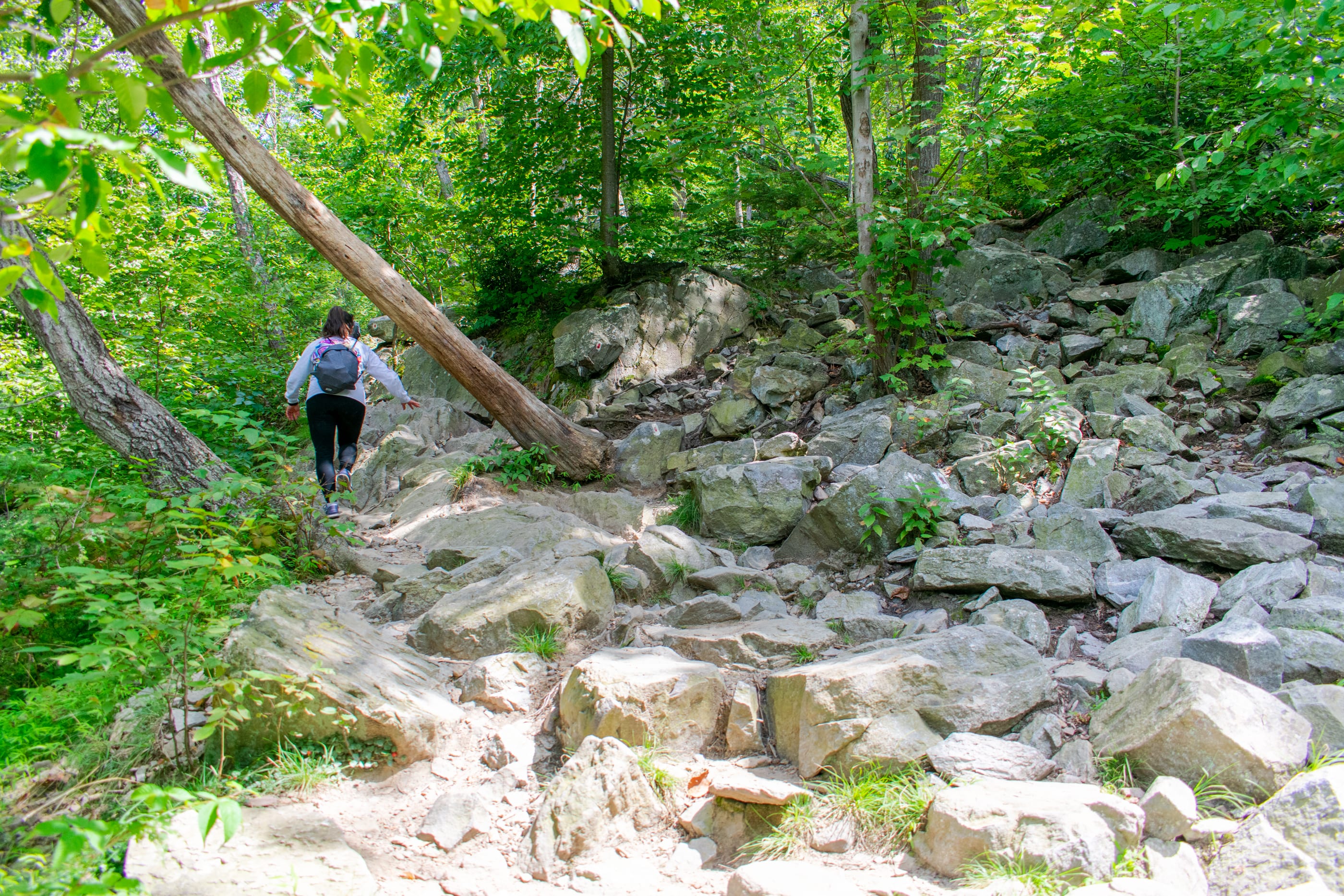
The Red Dot trail is great if you’re in the mood for a bit of adventure. Although it is not an ideal starting point for beginners, the ascent of this trail isn’t strenuous. However, make sure you have both hands free, because you will need them to help you climb at certain points. This isn’t daring rock climbing by any means, but having two hands free will be a lot safer.
Moreover, there are some points of interest (vistas) which serve as good resting spots while hiking the Red Dot trail. (In reality though, any point can be a rest point if you just lie down.) For example, one rest point provides a clear view of Mount Minsi across the Delaware River. In fact, you can also see the summit of Mount Tammany from this point. It looks so far away, but it’s really not much farther up the mountain, and it won’t feel far either.
A Note About Pets
Both the Red and Blue Dot trails are dog friendly. However, since the Red Dot trail is rocky, certain parts can be difficult for a dog to traverse. The hikers in front of me brought a Pomeranian; I didn’t see the owners pick up the dog once, though. In fact, she made it all the way to the summit on just her tiny legs. Behind me, one couple brought their older golden retriever. After trailing behind for a bit, they eventually beat me to the summit. (I stopped at the first vista, but they did not.) Going down the Blue Dot trail is a lot easier for dogs, too. So if you feel your dog can make it to the top, they’ll also make it back down with ease.
Marvel at Mount Minsi
Once you arrive at the summit, you’ll know it. This is where fellow hikers will be congregating, taking photos, and even eating. Here, you’ll have a clear view of Mount Minsi, Arrow Island, and a large portion of northeastern Pennsylvania. You’ll get some great photos, if you don’t mind a few people in your shot. (If you’re willing to be patient, though, you can take some really nice pics.)
Going down the Blue Dot trail is the perfect way to conclude this hike. It’s a bit longer than the Red Dot trail, without a doubt; but it’s not as intense and will give you a nice, long cooldown. Toward the end of the Blue Dot trail there is some running water. During the hot months, you can see people swimming in the water and having lunch at this spot. If you decide to join them, a word of caution; the water can get deep at certain points. I prefer sitting by the stream and taking a few moments to rest and rehydrate. From here, it’s only a short way out of the trail and into the Dunnfield Creek parking area.
There are porta potties in the Dunnfield Creek parking area, as well as restrooms outside the Kittatiny Point Visitor Center. Meanwhile, helpful state park employees are all around the area; they can provide you with maps and the best tips to hike safely and enjoyably. (You can also click here to find our list of the best safety tips for hiking in NJ.)
All Photos: © Patrick Lombardi / Best of NJ


